

Mgahinga Gorilla National Park
Nestled in the extreme south-western corner of Uganda, Mgahinga Gorilla National Park is a destination unlike any other on the African continent. At just 33.7 square kilometres, it is Uganda’s smallest national park, yet it packs an extraordinary punch — offering encounters with critically endangered mountain gorillas, rare golden monkeys, three towering dormant volcanoes, ancient Batwa cultural traditions, and spectacular Albertine Rift birdlife, all within a compact, intimate setting.
The park sits at the northern tip of the Virunga Massif, a chain of eight volcanoes that straddles the borders of Uganda, Rwanda, and the Democratic Republic of Congo (DRC). Together with Rwanda’s Volcanoes National Park and the DRC’s Virunga National Park, Mgahinga forms part of the Greater Virunga Transboundary Conservation Area — a UNESCO-designated World Heritage Site and one of the most biodiverse regions in Africa. The mountain gorillas that roam these interconnected forests have no regard for international boundaries, moving freely across all three countries.
Despite its small size, Mgahinga receives fewer tourists than Uganda’s more famous Bwindi Impenetrable National Park, making it a highly sought-after destination for travellers who prize exclusivity and an intimate safari experience. Gorilla trekking here feels remarkably personal — with strict limits on the number of daily visitors, your group will often feel alone in the forest with these magnificent primates.
Location & How to Get There
Geographic Position
Mgahinga Gorilla National Park is located in Kisoro District, at the southernmost tip of Uganda, bordering Rwanda to the south and the DRC to the west. The park’s main entrance is at Ntebeko Gate, approximately 10–15 km south of Kisoro town. The coordinates place the park between latitudes 1°19’S and 1°23’S and longitudes 29°34’E and 29°42’E.
Getting to Mgahinga from Kampala by Road
The most popular way to reach Mgahinga is by road from Kampala. The total distance is approximately 511 km, and the journey takes 8–10 hours depending on road conditions and stops. The main route follows the Kampala–Masaka–Mbarara–Kabale–Kisoro Highway:
- Kampala → Masaka: ~135 km (1.5–2 hours) on tarmac
- Masaka → Mbarara: ~132 km (1.5–2 hours) on tarmac
- Mbarara → Kabale: ~106 km (1.5 hours) — scenic highland road
- Kabale → Kisoro: ~55 km (1–1.5 hours) — winding mountain roads
- Kisoro → Ntebeko Gate (Mgahinga): ~15 km (20–30 minutes)
The road from Kabale to Kisoro winds through dramatic highland scenery but demands careful driving — the road is narrow and passes through steep terrain with sharp bends. Drivers must be confident and experienced. A 4WD vehicle is strongly recommended for the final sections, particularly during or after rain.
Getting to Mgahinga from Kigali, Rwanda
Mgahinga is surprisingly accessible from Kigali. The drive covers approximately 130 km via the Cyanika Border Post (Uganda–Rwanda) and takes around 4–5 hours. This makes Mgahinga an excellent addition to a Rwanda gorilla trekking itinerary in Volcanoes National Park — the two parks are effectively neighbours across the border.
Getting to Mgahinga by Air
Charter and scheduled domestic flights connect Entebbe International Airport to Kisoro Airstrip, with some flights stopping at Kihihi en route. Flight time from Entebbe is approximately 1–1.5 hours. From Kisoro airstrip, Ntebeko Gate is only 10–15 km away, requiring a short transfer by road. Several operators including Aerolink Uganda and Bar Aviation operate these routes. Flying is the fastest option and dramatically cuts travel time, though at a higher cost.
Ecology, Landscape & the Virunga Volcanoes
Vegetation Zones
Despite its compact size, Mgahinga encompasses a remarkable range of vegetation zones, rising from about 2,227 metres at the base to 4,127 metres at the summit of Mt. Muhavura. This dramatic altitudinal range creates a stacked sequence of habitats:
- Montane Forest (2,200–2,800 m): Dense, moist forests rich in Hagenia, Hypericum and tree ferns. Home to mountain gorillas, golden monkeys and many forest birds.
- Bamboo Forest (2,500–3,000 m): A key habitat for gorillas and golden monkeys, who feed heavily on bamboo shoots. Atmospheric and visually dramatic.
- Hagenia-Hypericum Forest (3,000–3,500 m): Open, parkland-like forest with mossy trees, giant lobelias and tree heathers.
- Alpine Moorland (3,500–4,000 m): Open grassland with giant groundsels, lobelias and everlasting flowers. Otherworldly scenery.
- Alpine Desert / Summit Zone (4,000 m+): Near-barren terrain at the highest peaks, with views across three countries.
The Three Virunga Volcanoes
Three of the eight Virunga volcanoes extend into Mgahinga. All are dormant (not currently active), though volcanic activity in the broader range (particularly in the DRC) is ongoing.
Mount Muhavura (4,127 m)
The highest peak in the park, Muhavura (which means “the guide” in Rufumbira) is a classic cone-shaped volcano and the third highest of the eight Virunga peaks. The summit ascent is a full-day challenge, taking 7–8 hours return. Hikers are rewarded with a small crater lake at the top and, on a clear day, panoramic views across Uganda, Rwanda and the DRC — including glimpses of Lake Edward and the Ruwenzori Mountains. Proper fitness and acclimatisation are essential. The steep trail passes through all major vegetation zones.
Mount Gahinga (3,474 m)
The park’s namesake volcano, Gahinga (meaning “a pile of stones” in local language), is the smallest of the three. Its summit hike takes around 5–6 hours return. A swampy crater at the summit hosts a beautiful bog lake, and the trails pass through some of the best bamboo forest in the park. The hike is moderately challenging — suitable for reasonably fit visitors.
Mount Sabinyo (3,645 m)
Perhaps the most dramatic of the three, Sabinyo (meaning “old man’s teeth” — a reference to its jagged, eroded peak) sits at the tri-border junction of Uganda, Rwanda and the DRC. The hike involves ladders and exposed ridgelines, making it the most technically demanding of the three, taking 6–8 hours return. At the summit, you can literally stand with one foot in each of three countries simultaneously — a bucket-list experience for serious hikers. The views from the ridge are absolutely spectacular.
Wildlife of Mgahinga Gorilla National Park
Mountain Gorillas
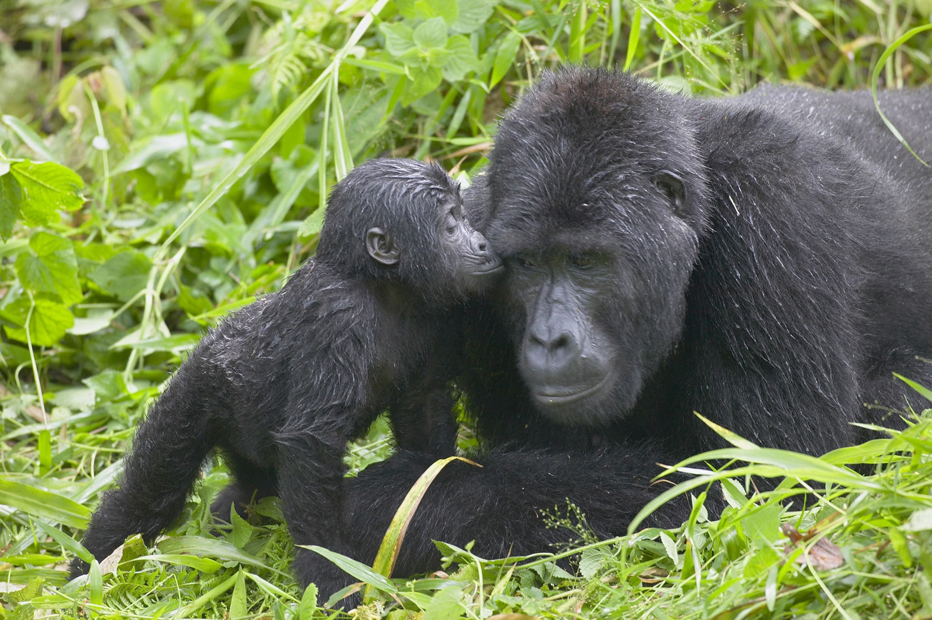
The mountain gorilla (Gorilla beringei beringei) is the star of Mgahinga. These are the largest living primates on earth, with adult males (silverbacks) weighing up to 220 kg and standing over 1.7 metres tall. Mountain gorillas are critically endangered — the entire wild population numbers only around 1,000–1,100 individuals, spread across the Virunga Massif and Uganda’s Bwindi Impenetrable Forest. Mgahinga is home to the Nyakagezi gorilla family, the park’s only fully habituated group. The family typically numbers 10–12 individuals, including one or more silverbacks, several adult females and their young.
Unlike the habituated groups at Bwindi, the Nyakagezi family historically ranged across the borders into Rwanda and the DRC. However, in recent years the family has settled more consistently on the Ugandan side, making reliable sightings increasingly common. Gorilla trekking in Mgahinga feels exceptionally intimate — only 8 permits are issued daily, and the experience of spending an hour with these gentle giants in their ancient forest home is widely regarded as one of the most profound wildlife encounters on earth.
Golden Monkeys
Mgahinga is one of the only two places in the world where you can track the rare and beautiful golden monkey (Cercopithecus kandti), the other being Rwanda’s Volcanoes National Park. This striking primate — with its vivid orange-gold back and black limbs — is endemic to the Albertine Rift and classified as endangered. Golden monkeys live in troops of 30–80 individuals and spend much of their time in the bamboo forests, feeding on bamboo shoots, leaves and fruit.
Two habituation programmes are available: the standard 1-hour golden monkey tracking experience (similar in format to gorilla trekking), and the golden monkey habituation experience, which allows visitors to spend 4 hours with the habituation team as they accustom a new monkey group to human presence. The habituation experience offers unparalleled photographic opportunities and a deeper understanding of primate research.
Other Mammals
While gorillas and golden monkeys headline the experience, Mgahinga supports a range of other mammals. Large mammals including forest elephants, leopards and African buffalo inhabit the park, though sightings are rare due to the dense vegetation. More commonly spotted species include giant forest hog, bushpig, black-fronted duiker, bushbuck and several species of mongoose. The Jackson’s chameleon, with its distinctive three-horned head, is a fascinating reptile often spotted by sharp-eyed guides.
Birdlife
For birdwatchers, Mgahinga is a hidden gem. The park sits in the heart of the Albertine Rift Endemic Bird Area, one of Africa’s most important ornithological zones. Over 180 bird species have been recorded in and around the park, including a remarkable concentration of Albertine Rift endemics. Key species to look out for include:
- Rwenzori turaco (Ruwenzori Turaco)
- Handsome francolin
- Kivu ground thrush
- Rwenzori batis
- Strange weaver
- Collared apalis
- Dusky crimsonwing
- African green broadbill (a top target for serious birders)
The Sabinyo Gorge and the wetland areas are particularly productive birding spots. Guided birding walks can be arranged at the park headquarters.
Activities & Experiences at Mgahinga
1. Gorilla Trekking
Gorilla trekking is the centrepiece experience at Mgahinga and arguably one of the greatest wildlife encounters in the world. Treks begin at 7:00 AM with a mandatory briefing at Ntebeko Gate Park Headquarters. Groups are limited to 8 people per day for the Nyakagezi family. After the briefing, rangers and trackers lead the group into the forest. Depending on where the gorillas have moved overnight, the trek can last anywhere from 1 to 6 hours each way. Once the gorilla family is located, visitors spend exactly 1 hour with the group.
Rules and etiquette during gorilla trekking:
- Maintain a minimum distance of 7 metres from the gorillas at all times
- No flash photography — cameras must be set to silent mode
- If you have a cold, respiratory infection or any contagious illness, you may not trek
- No eating or drinking within sight of the gorillas
- Do not stare directly into the eyes of a silverback — look away if he charges
- Follow ranger instructions at all times
- Maximum 1 hour with the gorillas regardless of conditions
- No children under 15 years of age
Gorilla permit fees (as of 2027–2028):
- Foreign non-residents: USD $800 per person
- Foreign residents of East Africa: USD $700 per person
- East African citizens: UGX 300,000 per person
Permits must be booked in advance through the Uganda Wildlife Authority (UWA) or a licensed tour operator. With only 8 permits available daily at Mgahinga, demand often exceeds supply — especially during peak season. Booking 3–6 months in advance is strongly recommended.
2. Golden Monkey Tracking
Golden monkey tracking offers a completely different but equally magical experience to gorilla trekking. Golden monkeys are fast-moving, gregarious and endlessly entertaining to watch as they leap through the bamboo canopy. The standard golden monkey tracking experience allows 1 hour with a habituated troop, while the golden monkey habituation experience lasts 4 hours and is perfect for wildlife photographers and primate enthusiasts.
3. Volcano Hiking
Three volcano hikes of varying difficulty are available. All hikes begin at Ntebeko Gate and are conducted with an armed ranger. A park entry fee applies in addition to the hiking fee.
- Mount Muhavura (4,127 m) — Very challenging | 7–8 hours return | Crater lake summit | Views of three countries
- Mount Gahinga (3,474 m) — Moderate | 5–6 hours return | Crater swamp summit | Best bamboo forest
- Mount Sabinyo (3,645 m) — Challenging | 6–8 hours return | Three-country summit | Ladders and exposed ridgeline
Hiking fee: USD $50–100 per person depending on the volcano (foreign non-residents). Guides and armed rangers are compulsory.
4. The Batwa Cultural Trail
One of Mgahinga’s most profound and moving experiences, the Batwa Cultural Trail is led by members of the Batwa — an indigenous people sometimes called the ‘Forest People’ — who lived as hunter-gatherers in the Virunga forests for thousands of years before the creation of the national parks displaced them. The trail visits Garama Cave, a 342-metre-long lava tube cave that served as a Batwa hideout and is deeply sacred to the community.
During the trail, Batwa guides demonstrate traditional forest skills including fire-making, medicinal plant use, hunting techniques and honey harvesting. The trail ends with a cultural performance of traditional songs and dances. This experience is not a zoo — it is a dignified, respectful sharing of a unique cultural heritage, and the fees contribute directly to Batwa community development.
Batwa Trail fee: Included in the park’s community tourism fees or approximately USD $50 per person (confirm with UWA).
5. Birdwatching Walks
Guided birdwatching walks can be arranged at Ntebeko Gate. Early morning walks (departing around 6:30–7:00 AM) offer the best sightings. Guides are knowledgeable about Albertine Rift endemic species and can direct you to the most productive habitats within and around the park. Bring binoculars, a field guide and a good camera with a telephoto lens.
6. Nature Walks & Community Visits
Shorter guided nature walks explore the lower slopes of the park and the surrounding community areas. These walks are excellent for botanical interest, birdwatching, and meeting local farmers who have lived alongside the park for generations. Community walks also visit local schools and women’s cooperatives.
Where to Stay Near Mgahinga
Luxury & Mid-Range Lodges
Accommodation options in and around Mgahinga range from basic to luxurious. The closest properties to the park gate are located between Kisoro town and Ntebeko Gate, while others are situated along the shores of scenic Lake Mutanda and Lake Bunyonyi (which is about 55 km from the park).
- Mount Gahinga Lodge — The only lodge directly at the park gate; luxury tented suites with an eco-focus. Iconic gorilla safari property.
- Kisoro Travellers Rest Hotel — Historic guesthouse in Kisoro town with a long history of hosting gorilla trekkers.
- Lake Mutanda Eco Resort — Mid-range; stunning lakeside setting with views of the volcanoes. 20 minutes from the gate.
- Mutanda Lake Resort — Budget-friendly option on Lake Mutanda; great for self-drive travellers.
- Lake Bunyonyi Rock Resort — Further away (55 km) but beautiful setting on Uganda’s most scenic lake.
For self-drive visitors, Kisoro town offers a range of guesthouses, budget hotels and eateries to suit all budgets. Book accommodation well in advance, particularly during the June–October peak season.
Best Time to Visit Mgahinga
Dry Seasons (Recommended)
- June to October — The long dry season; trails are drier and firmer, making trekking easier. July is the driest month. Very popular and permits sell out fast.
- December to February — The short dry season; a good alternative to the June–October peak with fewer visitors.
Wet Seasons (Less Ideal but Possible)
- March to May — Long rains; trails can be very muddy and slippery. Some visitors prefer the lush green scenery.
- September to November — Short rains; October is the wettest month. Permits may be more readily available.
Note that gorilla trekking is conducted year-round, regardless of season. Even in the wet season, determined gorilla trekkers go out in the rain. Waterproof gear and gaiters are essential in all seasons. The gorillas themselves are often more active and feed more visibly in the bamboo zone during the bamboo shoot season (usually around March–May), which some guides argue can make wet season trekking surprisingly rewarding.
CAR RENTAL GUIDE TO MGAHINGA GORILLA NATIONAL PARK
Self-Drive 4WD Hire, Road Routes & Driving Tips for Uganda’s Gorilla Heartland
Why Rent a Car to Mgahinga?
Self-driving to Mgahinga Gorilla National Park is one of the most rewarding road trips in East Africa. The route from Kampala to Kisoro passes through some of Uganda’s most spectacular scenery — the equatorial flatlands of Masaka, the rolling hills of Mbarara, the highland lakes of Kabale, and finally the dramatic volcanic landscape of Kisoro. A self-drive safari gives you complete freedom to stop and explore at your own pace, linger at scenic viewpoints, and experience authentic rural Uganda away from the tourist trail.
Renting a car is also significantly more cost-effective than booking a guided safari, particularly for groups of 2 or more sharing the vehicle costs. With the right vehicle, the right preparation and this guide in hand, the drive is entirely manageable for confident drivers.
Choosing the Right Vehicle
Selecting the appropriate vehicle is the single most important decision for a self-drive trip to Mgahinga. The roads from Kabale to Kisoro and beyond involve steep gradients, sharp bends and sections that become slippery in wet weather. A 4-wheel drive (4WD) vehicle is essential — a standard 2WD car is not suitable and may leave you stranded.
| Vehicle | Daily Rate (USD) | Best For | Terrain Suitability |
| Toyota RAV4 (4WD) | From $45/day | Solo travelers, couples (2–3 pax) | Good paved roads, light off-road |
| Toyota RAV4 + Camping Gear | From $55/day | 2 persons, budget camping | Light to moderate terrain |
| Toyota Land Cruiser Prado | From $70/day | Small groups, rugged terrain | Excellent – handles rough tracks |
| Land Cruiser Prado + Rooftop Tent | From $90/day | Camping safaris, 2–3 pax | Excellent – rugged terrain |
| Toyota Land Cruiser V8 | From $90/day | Families, groups up to 7 | Outstanding – all terrain |
| Toyota Hiace Minivan | From $60/day | Groups of 6–9 | Paved roads & moderate tracks |
Note: Prices are indicative and vary by operator, season and rental duration. Contact operators directly for current rates and availability.
Our Recommended Vehicle: Toyota Land Cruiser V8
For a family or group of up to 7 visiting Mgahinga, we recommend the Toyota Land Cruiser V8. This iconic East African safari vehicle combines supreme off-road capability with spacious comfort — essential for the long Kampala–Kisoro road trip and the final approach to the park gate. The high ground clearance, low-range 4WD and powerful engine handle the mountain roads of Kisoro with ease. It is also the preferred vehicle for carrying porter and equipment when volcano hiking.
For solo travellers or couples on a tighter budget, the Toyota RAV4 (4WD) is a practical choice for the paved main road. However, we advise upgrading to a Prado or V8 if you plan to drive any unpaved tracks beyond the main road to Ntebeko Gate, particularly during or after rain.
The Self-Drive Route: Kampala to Mgahinga
Route Overview
| KAMPALA → MGAHINGA ROUTE SUMMARY | |
| Total Distance | ~511 km (Kampala → Ntebeko Gate) |
| Estimated Drive Time | 8–10 hours (excluding stops) |
| Road Type | Paved tarmac Kampala–Kisoro; gravel/murram last 10–15 km |
| Fuel Stops | Masaka, Mbarara, Ntungamo, Kabale (fill up before Kisoro) |
| Overnight Option | Break the journey in Mbarara or Kabale |
Stage 1: Kampala to Masaka (~135 km, 1.5–2 hours)
Depart Kampala early — ideally by 6:00–7:00 AM — to avoid city traffic and maximise daylight driving time. Exit Kampala via the Entebbe Road / Kampala–Masaka Highway. The road is well-paved dual carriageway for much of this stretch. The equator crossing at Kayabwe is a popular photo stop. Masaka town is a convenient fuel and snack stop.
Stage 2: Masaka to Mbarara (~132 km, 1.5–2 hours)
Continue south-west on the Masaka–Mbarara Road. The road passes through Lake Victoria basin farmland with occasional views of the lake. Mbarara is the largest city in western Uganda — a good stop for a full meal, fuel top-up and rest. The drive is scenic and comfortable on good tarmac.
Stage 3: Mbarara to Kabale (~106 km, 1.5–2 hours)
From Mbarara, head south on the Mbarara–Kabale road via Ntungamo. The landscape changes dramatically as you enter Uganda’s highland region, with terraced hills, tea plantations and mist-covered valleys. Kabale — the highest town in Uganda at ~1,900 m — is a charming stop. Lake Bunyonyi, one of Africa’s most beautiful lakes, is just 7 km from Kabale town. Many self-drive visitors break their journey here for a night.
Stage 4: Kabale to Kisoro (~55 km, 1–1.5 hours)
This is the most challenging and most beautiful stage of the drive. The road between Kabale and Kisoro winds over the Muko–Muramba highlands through some of Uganda’s most dramatic mountain scenery. The road is paved but narrow, with tight bends, steep gradients and occasional landslide debris after heavy rain.
Driving tips for this section:
- Drive slowly and use low gear on descents — do not ride the brake
- Sound your horn on blind corners (this is standard practice on these roads)
- Watch for motorcycles (boda-bodas) on the inside of bends
- If driving at night, use full headlights and reduce speed significantly
- Fill up with fuel in Kabale — fuel availability in Kisoro can be limited
Stage 5: Kisoro to Ntebeko Gate (~15 km, 20–30 minutes)
From Kisoro town, follow signs towards Mgahinga Gorilla National Park. The road initially passes through farmland before entering the park’s buffer zone. The last 5–8 km to Ntebeko Gate involves a murram (gravel) road that can be muddy after rain. 4WD low-range may be required on the approach to the gate during the wet season. The gate is at approximately 2,227 m elevation, and the air is noticeably cooler and fresher.
Self-Drive Road Conditions & Driving Tips
Road Conditions by Season
- Dry season (June–October, December–February): Main roads are in good condition. Murram sections are dusty but firm. Standard 4WD mode usually sufficient.
- Wet season (March–May, September–November): Main roads remain passable. The Kabale–Kisoro section can be very slippery after heavy rain. The murram approach to Ntebeko Gate may require 4WD low-range. Take extra care.
General Driving Tips for Uganda Self-Drive
- Drive on the left-hand side of the road
- Speed limits: 80 km/h on highways, 50 km/h in towns — traffic police with speed guns are present
- Carry your driving licence, rental agreement, insurance documents and passport at all times
- Police checkpoints are common — stop, greet the officer politely, and present documents as requested
- Avoid driving at night — animals, pedestrians and unlit cyclists are major hazards
- Fuel up whenever you have the opportunity — do not let the tank drop below half in remote areas
- Keep a spare tyre and basic tools in the vehicle — tyre punctures on murram roads are common
- Download Google Maps or Maps.me offline for the route before departing — mobile data can be patchy
- Carry Ugandan shillings for small purchases, local eateries and roadside emergencies
What to Pack in Your Vehicle
- First-aid kit
- Jerry can with extra fuel (especially for remote sections)
- Spare tyre (confirm with rental company it is included)
- Jump leads
- Water (at least 2 litres per person per day)
- Snacks and packed lunch — few restaurants between Kabale and Kisoro
- Rain gear (waterproof jacket and gaiters for gorilla trekking)
- Warm layers — Kisoro elevation means cool evenings
- Phone charger and power bank
When booking a rental vehicle, ask about:
- Insurance coverage (third-party and comprehensive)
- Whether a driver/guide is available as an option
- Vehicle delivery to Kisoro (some operators offer this service)
- What happens in the event of a breakdown
- Whether a rooftop tent is available if you plan to camp
Practical Tips for Visiting Mgahinga
What to Wear for Gorilla Trekking
- Long-sleeved shirt and long trousers (protects from nettles and insects)
- Waterproof jacket (essential — the forest is frequently wet)
- Sturdy, ankle-supporting hiking boots with grip
- Gaiters (highly recommended — protects ankles from thorns and mud)
- Gardening or leather gloves (for grabbing vegetation on steep sections)
- Hat or cap
- No bright colours — subdued greens, browns and khakis are ideal
What to Bring for Trekking
- Camera (no flash) — DSLR or mirrorless with silent shutter mode
- Water (minimum 2 litres)
- Energy snacks, chocolate or energy bars
- Small day pack / backpack
- Bug repellent (DEET-based)
- Sunscreen
- Walking stick (available for hire at the gate)
Health & Safety
- No specific vaccinations are required, but Yellow Fever vaccination is recommended (and may be checked at border crossings)
- Malaria prophylaxis is advised — consult your doctor before travel
- Altitude: Mgahinga sits at over 2,200 m — allow 1–2 days to acclimatise if arriving from low elevation
- Do not trek if you have a cold, flu or any respiratory illness — to protect the gorillas from human disease
- Mountain rescues are rare but can occur on the higher volcano hikes — ensure your travel insurance covers mountain rescue
Combining Mgahinga with Other Destinations
Mgahinga’s location in Uganda’s south-west makes it an ideal component in a wider East Africa safari itinerary. Popular combinations include:
- Mgahinga + Bwindi Impenetrable National Park: Uganda’s two gorilla parks. Drive or fly between them (Bwindi’s Nkuringo sector is ~1–2 hours from Kisoro). Double your chances of permits and compare the two gorilla trekking experiences.
- Mgahinga + Rwanda’s Volcanoes National Park: Cross the Cyanika border post (~2 hours from Mgahinga) and trek gorillas in the Rwandan Virunga. A seamless cross-border extension.
- Mgahinga + Lake Bunyonyi: Uganda’s most scenic lake is just 55 km from Kisoro. Ideal for relaxation before or after the trek — kayaking, island hopping and swimming.
- Mgahinga + Queen Elizabeth National Park: Continue to Queen Elizabeth for the classic big-five savannah experience, including the famous tree-climbing lions of Ishasha. ~4–5 hours from Kisoro.
- 7–10 day Southwest Uganda Circuit: Mgahinga + Bwindi + Lake Bunyonyi + Queen Elizabeth + Kibale Forest (chimpanzee trekking). The ultimate Uganda safari loop.
Conclusion
Mgahinga Gorilla National Park may be Uganda’s smallest national park, but it delivers some of the most extraordinary wildlife encounters on the planet. From the deeply moving hour spent with the Nyakagezi gorilla family in their ancient volcanic forest, to the exhilaration of standing at the tri-border summit of Mount Sabinyo, to the humbling privilege of sharing the Batwa cultural trail with the forest people — Mgahinga is a destination that leaves a permanent imprint on the soul.
Self-driving to Mgahinga aboard a well-chosen 4WD rental vehicle adds another dimension to the adventure — the freedom to travel at your own pace through some of East Africa’s most spectacular highland scenery. With the right preparation, the right vehicle and an early booking of your gorilla permit, a self-drive trip to Mgahinga Gorilla National Park is entirely achievable and deeply rewarding.
Book your gorilla permits early. Pack your waterproof jacket. Point your Land Cruiser south-west. The gorillas of Mgahinga are waiting.